Historical Collections Online
Search our Historical Collections Online, a sample of 10,000 artefacts from the National Museum of Ireland’s Historical, Military and Easter Week Collections, published as part of the Decade of Commemorations.
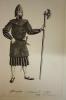
illustration / Gallowglass, professional soldier, end 15th century
Print, Gallowglass, professional soldier, end 15th century. Positive print. One of a set of six illustrations, in positive and negaitve print, of Irish traditional dress. Irish girl, late 15th century. Light armed non-professional soldier, early 16th century. Irish gentlewoman, early 16th century. ...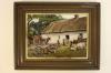
photograph / Traditional Irish cottage
Coloured photograph, probably early 19th century. Scene outside a traditional Irish cottage, whitewashed and thatched. Man seated on a small cart drawn by a donkey, a woman seated outside the door, an elderly woman spinning, and in the bakcground two men on a jaunting car. Includes cows and pigs.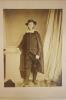
photograph / unidentified man
Portrait photograph, full length, studio, of an unidentified man.
photograph / unidentified man
Photographic portrait, bust, of an unidentified man. Photographer's stamp of the reverse - Alex Redding, 18 Lower Beechwood Avenue, Ranelagh, Dublin.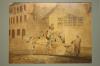
painting / Delivering Milk
Print of a painting, Irish village street scene, delivering milk from a donkey drawn flatbed cart with block wheels. Milk drawn from a staved vessel, poured into the various type vessels of the customers.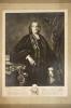
print / Reverend Samuel Madden
Photograph of a portrait, of the Reverend Samuel Madden D.D. (1686-1765), writer and co-founder of the Royal Dublin Society. Original by Spooner of Dublin, 1752.
photograph / Group, 1908
Photograph, group, black and white, by Lafayette of Dublin. Group of ladies and gentlemen posed outside a house. Dated 1908 in pencil underneath.
portrait / unidentified male
Photographic portrait, head and shoulders, black and white, of male. To be identified. Initialled A.M.G.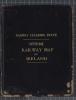
railway map / Official Railway Map of Ireland, 1918
Copy of the Official Railway Map of Ireland. Prepared and published at The Railway Clearing House, London, 1918. Drawn and engraved by J. and W. Emslie, London. Leather bound, with text in gold.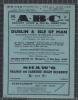
railway timetable / A.B.C. Railway Guide and Hotel Directory, 1940
Copy of the A.B.C. Railway Guide and Hotel Directory, for Dublin and the Isle of Man, Scotland and North of England via Silloth. August 1940. Printed and published by Falconer, 2 Crow Street, Dublin.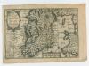
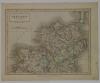
map / The Kingdom of Ireland
Map of Ireland, probably 18th century. Titled ‘The Kingdome of Ireland’. Also showing Part of Scotland, and Wales as Part of England. Numbered in corner 10. On back a text titled ‘Ireland Described Chapter 1’.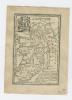
map / The Kingdom of Ireland, 1792
Map of Ireland, probably 18th century. Titled ‘Ireland. The Kingdom of Ireland is divided into 4 Provinces and subdivided into 32 Counties. Tis 275 miles in Length, 169 in Breadth and contains 27, 487 square miles. The Protestant is the established religion and the Roman Catholick tolerated’. ...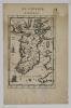
map / Isle d’Irelande
Map of Ireland, one of three, probably 18th century. Titled ‘Isle d’Irelande Royavme d’Irelande’. From a book ‘De L’Europe’. Page 9, Figure IV. Numbered in corner 7.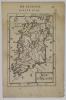
map / Isle d’Irelande
Map of Ireland, one of three, probably 18th century. Titled ‘Isle d’Irelande Royavme d’Irelande’. From a book ‘De L’Europe’. Page 47, Figure XXIII. Numbered in corner 8.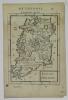
map / Isle d’Irelande
Map of Ireland, one of three, probably 18th century. Titled ‘Isle d’Irelande Royavme d’Irelande’. From a book ‘De L’Europe’. Page 49, Figure XXIV. Numbered in corner 9.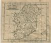
map / Ireland
Map of Ireland, possibly 18th or early 19th century. Titled ‘Ireland’. Numbered in corner 24.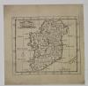
map / Ireland
Map of Ireland, possibly 18th or early 19th century. Titled ‘Ireland’. Numbered in corner 23.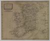
map / Ireland from the best Authorities
Map of Ireland, possibly 18th or early 19th century. Titled ‘Ireland from the best Authorities’. Numbered in corner 28.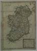
map / A New Map of Ireland, 1716
Map of Ireland, 18th century. Titled ‘A New Map of Ireland, Humbly Dedicated to the Right Honorable Charles Boyle, Earle of Orrery & c. by his Honorable most Humble Servant Thomas Baknell 1716’. Showing Archbishopricks, Bishopricks and Universities. Numbered in corner 15. Coloured.