Historical Collections Online
Search our Historical Collections Online, a sample of 10,000 artefacts from the National Museum of Ireland’s Historical, Military and Easter Week Collections, published as part of the Decade of Commemorations.
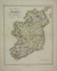
map / Ancient and Modern Ireland, 1821
Map of Ireland, 19th century. Titled ‘Ancient and Modern Ireland’, drawn and engraved for Dr Playfair’s Atlas. Engraved by B. Smith, Walworth, near London. Published by Macredie Skelly & Co., Edinburgh, 1821. Colour. Numbered in corner 45.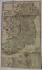
map / A New Map of Ireland, 1714
Map of Ireland, 18th century. Titled ‘A New Map of Ireland’, divided into its Provinces, Counties and Baronies, wherein are distinguished the Bishopricks, Borroughs, Barracks, Bogs, Passes, Bridges & etc, with the Principal Roads, and the common reputed miles. According to the newest and most exact...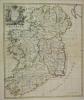
map / A New Map of Ireland, 1720
Map of Ireland, 18th century. Titled ‘A New Map of Ireland’, from the latest observations, by John Senax, inscribed to the Roght Honourable Simon Lord Lovat. 1720. Colour.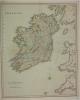
map / Ireland
Map of Ireland, 19th century. Titled ‘Ireland’, published in London by Henry Teesdale & Co., 302 Holborn. Colour. Numbered in corner 46.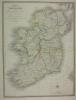
map / Ireland, 1841
Map of Ireland, 19th century. Titled ‘A Map of Ireland’ divided into Provinces and Counties’, shewing the Great and Cross Roads, with the distances of the principle towns from Dublin. Also the Steam Communications from the Out Ports, and the average time of passage. Published by J. Wyld (successor...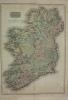
map / Ireland, 1813
Map of Ireland, early 19th century. Titled ‘Ireland’. Drawn under the direction of Mr Pinkerton, by L. Herbert. Engraved by Neale at 352 Strand, London. For Pinkerton’s Modern Atlas. Published 13 September 1813 by Cadell & Davies of Strand and Longman, Hurst, Rees, Orme and Brown of Paternoster...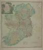
map / A New Map of Ireland’ divided into Provinces, Counties, 1798
Map of Ireland, late 18th century. Titled ‘A New Map of Ireland’ divided into Provinces, Counties, by Thomas Kitchen, Geographer, Hydrographer to His Majesty. Published 12 May 1798 by Laurie & Whittle, No. 53 Fleet Street, London. Colour. Numbered in corner 33.
advertisement / The Historical Atlas of Ireland, c.1862
Printed notice, advertising the publication of ‘The Historical Atlas of Ireland’. Containing The Atlas of Ulster, executed in 1609, in 31 maps. Two ancient maps of Ireland circa 1566. Copy of a portion of an ancient manuscript in the British Museum by Dean Laurence Nowell, being the text to...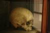
human remains / Turlough O’Carolan
Skull of Turlough O’Carolan, the Irish Harpist. In display case.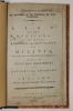
list / List of the Officers of the Several Regiments and Battalions of Militia, 1795
Book. A List of the Officers of the Several Regiments and Battalions of Militia, with the dates of their respective commissions and also of the fencible regiments of Cavalry and Infantry of Ireland, with an alphabetical index. Printed in Dublin by James King and Abraham Bradley King, no. 72 Dame...
mask / Lord Plunkett
Full head plaster cast death mask of Lord Plunkett, 1912.
photograph / Liam Cosgrave
Framed photograph of Liam Cosgrave T.D. From the Cosgrave Family Collection. "E.O. Happe" inscribed bottom left.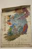
geological map / Ireland
Geological map of Ireland. Diagramatic section across Ireland from the north coast of Mayo to Carnsore Point in Wexford. Based on the work of the Geological Survey. 3rd Edition, 1962. Scale 1:750,000. Published by the Government of Ireland, 1985.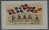
drawing / Irish Brigades in France, 1770
The Irish Brigades in France, 1770. Coloured print depicting 5 uniformed men under their flags with the legend below "Les Regiments de Bulkeley, de Roscommon, de Dillon, de Berwick, et de Clare - (Irlandais) - on 1770.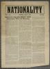
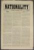
newspaper / Nationality, Vol. 1, No. 1
File of Nationality 1915/16 comprising vol. 1 nos. 1-17, 19, 20, 25-31, 32 (pp. 3-8 only), 33-39, 41, 43-45.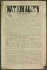
newspaper / Nationality, Vol. 1, No. 10
File of Nationality 1915/16 comprising vol. 1 nos. 1-17, 19, 20, 25-31, 32 (pp. 3-8 only), 33-39, 41, 43-45.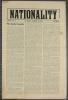
newspaper / Nationality, Vol. 1, No. 11
File of Nationality 1915/16 comprising vol. 1 nos. 1-17, 19, 20, 25-31, 32 (pp. 3-8 only), 33-39, 41, 43-45.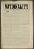
newspaper / Nationality, Vol. 1, No. 12
File of Nationality 1915/16 comprising vol. 1 nos. 1-17, 19, 20, 25-31, 32 (pp. 3-8 only), 33-39, 41, 43-45.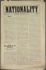
newspaper / Nationality, Vol. 1, No. 13
File of Nationality 1915/16 comprising vol. 1 nos. 1-17, 19, 20, 25-31, 32 (pp. 3-8 only), 33-39, 41, 43-45.