Historical Collections Online
Search our Historical Collections Online, a sample of 10,000 artefacts from the National Museum of Ireland’s Historical, Military and Easter Week Collections, published as part of the Decade of Commemorations.

map / Marchand's Voyage 1790 - 92, Plates I - VIII
"Marchand's Voyage 1790 - 92, Plates I - VIII". Book of maps and charts, some fold-out, inscribed in pencil in inner page "Geo Buckett"
map / A survey of the ....... and Buildings contigious to the Parliament House Dublin by Thomas Sherrard Surveyor to the Commissioners of WideSstreets in said city, 1802
Plan, engraved and tinted; "A survey of the ....... and Buildings contigious to the Parliament House Dublin by Thomas Sherrard Surveyor to the Commissioners of Wide Streets in said city, 1802". In three sections. Titled 'A Survey of the City of Dublin taken by order of The Right Honorable and...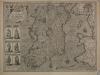
map / The Kingdome of Ireland, 1610
Map of Ireland, early 17th century. Titled ‘The Kingdome of Ireland’, divided into severall Provinces, and then again divided into Counties. Newly described. Performed by John Speede and are to be sold in Pope’s Head Alley by John Sudbury and George Humble. Dated 1610. With illustrations of the...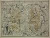
map / The Province of Ulster Described, 1610
Map of Ireland, early 17th century. Titled ‘The Province of Ulster Described’. With a detail map of Enniskilling Fort at Lough Erne. Performed by John Speede and are to be sold in Pope’s Head Alley by John Sudbury and George Humble. Dated 1610.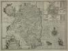
map / The Countie of Leinster with the Citie Dublin Described, 1610
Map of Ireland, early 17th century. Titled ‘The Countie of Leinster with the Citie Dublin Described’. With a detail map of Dublin City. Performed by John Speede and are to be sold in Pope’s Head Alley by John Sudbury and George Humble. Dated 1610.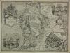
map / The Province of Connaught with the Citie of Galwaye Described, 1610
Map of Ireland, early 17th century. Titled ‘The Province of Connaught with the Citie of Galwaye Described’. With a detail map Galway City. Performed by John Speede and are to be sold in Pope’s Head Alley by John Sudbury and George Humble. Dated 1610.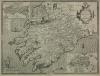
map / The Province of Mounster, 1610
Map of Ireland, early 17th century. Titled ‘The Province of Mounster’. With detail maps of Cork and Limerick Galway Cities. Performed by John Speede and are to be sold in Pope’s Head Alley by John Sudbury and George Humble. Dated 1610.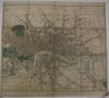
map / Cary's London, 1833
Cary's New Map of London and its Adjacent Villages, Published by order of His Majesty's Postmaster General, showing the present boundary of the Two-Penny Post Delivery, and the limits of the Hackney Coach back fares. London, G. and J. Cary, 86 St James Street.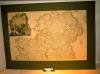
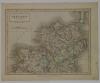
map / Ireland
Map of Ireland; the northern half. Ulster, North Leinster and North Connaught. Titled 'A Map of the Kingdom of Ireland, divided into provinces, counties and baronies, showing th Archbishopricks, Bishopricks, Cities, Boroughs, Market Towns, Villages, Barracks, Mountains, Lakes, Bogs, Rivers,...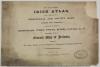
atlas / New and Correct Irish Atlas, c.1825
Set of Irish maps, with the title "New and Correct Irish Atlas, being a complete set of provincial and county maps, Divided into Baronies, containing the principal cross-roads, cities, towns, rivers, canals &c. &c. together with a General map of Ireland; shewing the relative situation of each...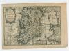
map / The Kingdom of Ireland
Map of Ireland, probably 18th century. Titled ‘The Kingdome of Ireland’. Also showing Part of Scotland, and Wales as Part of England. Numbered in corner 10. On back a text titled ‘Ireland Described Chapter 1’.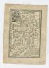
map / The Kingdom of Ireland, 1792
Map of Ireland, probably 18th century. Titled ‘Ireland. The Kingdom of Ireland is divided into 4 Provinces and subdivided into 32 Counties. Tis 275 miles in Length, 169 in Breadth and contains 27, 487 square miles. The Protestant is the established religion and the Roman Catholick tolerated’. ...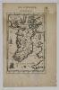
map / Isle d’Irelande
Map of Ireland, one of three, probably 18th century. Titled ‘Isle d’Irelande Royavme d’Irelande’. From a book ‘De L’Europe’. Page 9, Figure IV. Numbered in corner 7.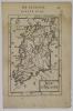
map / Isle d’Irelande
Map of Ireland, one of three, probably 18th century. Titled ‘Isle d’Irelande Royavme d’Irelande’. From a book ‘De L’Europe’. Page 47, Figure XXIII. Numbered in corner 8.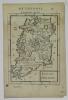
map / Isle d’Irelande
Map of Ireland, one of three, probably 18th century. Titled ‘Isle d’Irelande Royavme d’Irelande’. From a book ‘De L’Europe’. Page 49, Figure XXIV. Numbered in corner 9.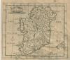
map / Ireland
Map of Ireland, possibly 18th or early 19th century. Titled ‘Ireland’. Numbered in corner 24.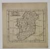
map / Ireland
Map of Ireland, possibly 18th or early 19th century. Titled ‘Ireland’. Numbered in corner 23.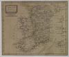
map / Ireland from the best Authorities
Map of Ireland, possibly 18th or early 19th century. Titled ‘Ireland from the best Authorities’. Numbered in corner 28.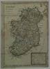
map / A New Map of Ireland, 1716
Map of Ireland, 18th century. Titled ‘A New Map of Ireland, Humbly Dedicated to the Right Honorable Charles Boyle, Earle of Orrery & c. by his Honorable most Humble Servant Thomas Baknell 1716’. Showing Archbishopricks, Bishopricks and Universities. Numbered in corner 15. Coloured.