Historical Collections Online
Search our Historical Collections Online, a sample of 10,000 artefacts from the National Museum of Ireland’s Historical, Military and Easter Week Collections, published as part of the Decade of Commemorations.
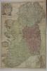
map / Ireland
Map of Ireland, early 19th century. Titled ‘Ireland’. By S. Hall. Published in London by Longman & Co. Colour. Numbered in corner 59.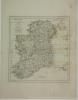
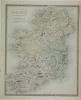
map / Ireland, divided into Provinces, subdivided into counties, 1774
Map of Ireland, 18th century. Titled ‘Ireland, divided into Provinces, subdivided into counties’. By Samuel Dunn, Mathematician. Printed in London for Robert Sayer of 53 Fleet Street as the Act directs, 10 January 1774. Numbered in corner 7.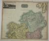
map / Northern Part of Ireland, 1817
Map of Ireland, 19th century. Titled ‘Northern Part of Ireland’. Drawn and engraved by N.R. Hewitt, Grafton Street East, Totenham Court Road, London. Drawn and engraved by Thompson’s New General Atlas, 1817. No. 10, Part 1. Includes a view of the Giants Causeway in the County of Antrim. Colour....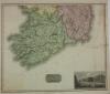
map / Southern Part of Ireland, 1817
Map of Ireland, 19th century. Titled ‘Southern Part of Ireland’. Drawn and engraved by N.R. Hewitt, Grafton Street East, Totenham Court Road, London. Drawn and engraved for Thompson’s New General Atlas, 1817. No. 10, Part 2. Includes a view of the Bank of Ireland, Dublin. Colour. Numbered in corner...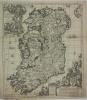
map / Hyberniae
Map of Ireland, 18th century. Titled ‘Hyberniae’. Regni in Provincias Ultoniam, Connachtam, Lageniam, Momoniamo, divisi Tabula accuratissima, editore Covens et Mortier Amstelo-Batavo. t’Amsteldam by I. Covens en C. Mortier op de Vygendam, met Privileie vande Edele GrootMogende Keeren, Staaten van...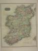
map / Ireland, 1815
Map of Ireland, 19th century. Titled ‘Ireland’. Engraved by Neale, published at Strand, London. Drawn and engraved for Thompson’s New General Atlas, 1815. No. 10. Colour. Numbered in corner 43.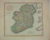
map / A New Map of Ireland, 1799
Map of Ireland, 18th century. Titled ‘A New Map of Ireland’, divided into its Provinces and Counties; also, The Opposite Coasts of Scotland and Wales; shewing the several ports from where the packets depart for Ireland. From the latest authorities. By John Carey, engraver, 1799. Printed in London...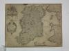
map / Hibernia Regnum Vulgo Ireland
Map of Ireland, 17th or early 18th century. Titled ‘Hibernia Regnum Vulgo Ireland’.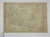
map / Eryn Hiberniae Britannicae Insvlae Nova Descriptio Irlandt, 1572
Map of Ireland, 16th or 17th century. Titled ‘Eryn Hiberniae Britannicae Insvlae Nova Descriptio Irlandt’. As mapped, 1572. Library stamp in corner.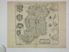
map / A Mapp of the Kingdom of Ireland, 1673
Map of Ireland, 1th century. Titled ‘A Mapp of the Kingdom of Ireland’ by Richard Blome, by His Majesty’s Commission. Engraved by R. Palmer. Dated 1673. Numbered in corner 5.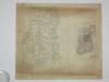
map / Copy of an Ancient Map in the British Museum, Ireland, 1862
Map of Ireland, copy, 16th century. Titled ‘Copy of an Ancient Map in the British Museum (Domitian A 18 f.f. 101 103), by Laurence Nowell, Dean of Lichfield (ob. 1576). Lithographed and printed at the Topographical Department of the War Office by Colonel Sir H. James. Produced circa 1862. Colour.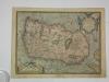
map / Eryn Hiberniae Britannicae Insvlae Nova Descriptio Irlandt, copy
Map of Ireland, 16th or 17th century. Titled ‘Eryn Hiberniae Britannicae Insvlae Nova Descriptio Irlandt’. Colour copy of the 1572 version.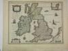
map / Magnae Britanniae et Hiberniae
Map of Ireland, 17th or 18th century. Titled ‘Magnae Britanniae et Hiberniae’, Colour. Numbered in corner 3.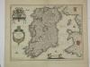
map / Hibernia Regnum Vulgo Ireland
Map of Ireland, 18th century. Titled ‘Hibernia Regnum Vulgo Ireland’. Colour. Numbered in corner 3.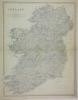
map / Ireland
Map of Ireland, 19th century. Titled ‘Ireland’, by Keith Johnston F.R.S.E. Engraved and printed by W. and A. K. Johnston, Edinburgh. Published by William Blackwood and Sons of Edinburgh and London. For Keith Johnston’s General Atlas. Colour.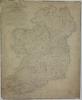
map / A Topographical and Historical Map of Ancient Ireland
Map of Ireland, late 18th or early 19th century. Titled ‘A Topographical and Historical Map of Ancient Ireland’. Shewing the Five Kingdoms of the Pentarchy Meath, Ulster, Connaught, Leinster and Munster, as tey existed under the Milesian Kings with the old Principalities and other Chief Divisions,...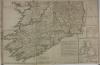
map / The Sea Coasts of Great Britian and Ireland
Map of Ireland, 18th century. Titled ‘The Sea Coasts of Great Britian and Ireland’. Published in London by Robert Sayer, opposite Fetter lane, Fleet Street. Colour. Numbered in corner 20.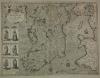
map / The Kingdome of Ireland, 1610
Map of Ireland, early 17th century. Titled ‘The Kingdome of Ireland’, divided into severall Priovinces, and then again divided into Counties. Newly described. Performed by John Speede and are to be sold in Pope’s Head Alley by John Sudbury and George Humble. Dated 1610. With illustrations of the...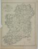
map / Map of Ireland, 1837
Map of Ireland, 19th century. Titled ‘Map of Ireland’, divided into Provinces and Counties, shewing the Principal Roads, Railways, Rivers and Canals, and the distance in Irish Miles and Furlongs of each city and Post Town from Dublin. For Lewis’s Atlas of Ireland. Drawn by R. Creighton, engraved by...