Historical Collections Online
Search our Historical Collections Online, a sample of 10,000 artefacts from the National Museum of Ireland’s Historical, Military and Easter Week Collections, published as part of the Decade of Commemorations.
map / Ireland divided into Provinces and Counties: from the best Authorities, 1802
Map of Ireland, early 19th century. Titled ‘Ireland divided into Provinces and Counties: from the best Authorities'. By J. Russell. 1802. Numbered in corner 37.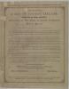
advertisement / A Map of Ancient Ireland
Printed notice, advertising the publication of A Map of Ancient Ireland, printed from the original copper plate, engraved in the reign of Queen Elizabeth about the year 1572. Published by John Corry, Armagh. Sold by the publisher and Mr McWatters, printer, bookseller and etc Armagh, also by Mr...
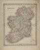
map / Ireland
Map of Ireland, early 19th century. Titled ‘Ireland’. Showing corporate towns, corporate and parliamentary towns, county boundaries and water. With population figures for several towns. Engraved by Michael Sancys(?). Printed by H. Martin. Signed at the end, Thomas Alaram(?), Lieutenant Royal...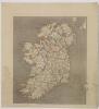
map / A New Map of Ireland, 1811
Map of Ireland, early 19th century. Titled ‘A New Map of Ireland’. Published by William Dart of 58 Holborn Hill, London, 23 September 1811. Colour.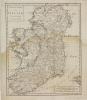
map / Nieuwe Kaart van Ierland
Map of Ireland, early 19th century. Titled ‘Nieuwe Kaart van Ierland’. Te Amsterdam. By Isaak Tirion. Numbered in corner 18.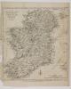
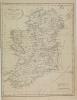
map / A New and Accurate Map of the Kingdom of Ireland, with the Roads, from the Latest Surveys, 1782
Map of Ireland, late 18th century. Titled ‘A New and Accurate Map of the Kingdom of Ireland, with the Roads, from the Latest Surveys’. Published as the Act Directs, by J. Bew, Paternoster Row, London, 30 April, 1782. Engraved by John Lodge(?). Numbered in corner 27.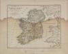
map / Ireland, 1855
Map of Ireland, 19th century. Titled ‘Ireland’. Entworsen und gezeichnet von F. von Stulpnagel, 1855. Githa Justus Perthes. Engraved by C. Metzeroth. Colour. Numbered in corner 63.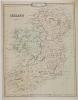
map / Ireland, Crunchley’s Improved Atlas for Schools and Families, 1841
Map of Ireland, 19th century. Titled ‘Ireland’. Crunchley’s Improved Atlas for Schools and Families. Engraved and published by G.F. Crunchley, Mapseller, 81 Fleet Street, London. 1 January 1841. Colour. Numbered in corner 56.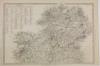
map / Ireland (North), 1838
Map of Ireland, 19th century. Titled ‘Ireland’. (North) Published by the Society for the Diffusion of Useful Knowledge, 55 Lincolns Inn Fields, London, 15 March 1838. Engraved by J. and C. Walker. Published in two sheets, north and south. Colour. Numbered in corner 51.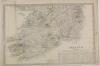
map / Ireland (South), 1838
Map of Ireland, 19th century. Titled ‘Ireland’. (South) Published by the Society for the Diffusion of Useful Knowledge, 55 Lincolns Inn Fields, London, 15 March 1838. Engraved by J. and C. Walker. Published in two sheets, north and south. Colour. Numbered in corner 51.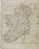
map / Ireland Divided in Provinces and Counties, from the best Authorities, 1785
Map of Ireland, late 18th century. Titled ‘Ireland Divided in Provinces and Counties, from the best Authorities’. Published as the Act direct by C. Dilly and G. Robinson, London, 1 January 1785. Numbered in corner 30.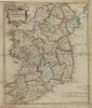
map / The Kingdom of Ireland
Map of Ireland, late 18th century. Titled ‘The Kingdom of Ireland’. By Robert Morden. Sold by Abel Swale Awnsham and John Churchill. Colour. Numbered in corner 11.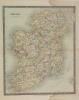
map / Ireland, 1831
Map of Ireland, 19th century. Titled ‘Ireland’. Drawn and engraved by J. Dower, Pentonville, London. Published by Henry Teesdale & Co., 302 High Holburn, London, March 1831. Colour. Numbered in corner 50.
map / Ireland (North)
Map of Ireland, early 19th century. Titled ‘Ireland’. (North) By Edward Weller, F.R.G.S. Lithographer. Weekly Dispatch Atlas, 139 Fleet Street, London. In four sheets, north, south, east and west. Numbered in corner 61.map / Ireland (South)
Map of Ireland, early 19th century. Titled ‘Ireland’. (South) By Edward Weller, F.R.G.S. Lithographer. Weekly Dispatch Atlas, 139 Fleet Street, London. In four sheets, north, south, east and west. Numbered in corner 61.map / Ireland (East)
Map of Ireland, early 19th century. Titled ‘Ireland’. (East) By Edward Weller, F.R.G.S. Lithographer. Weekly Dispatch Atlas, 139 Fleet Street, London. In four sheets, north, south, east and west. Numbered in corner 61.map / Ireland (West)
Map of Ireland, early 19th century. Titled ‘Ireland’. (West) By Edward Weller, F.R.G.S. Lithographer. Weekly Dispatch Atlas, 139 Fleet Street, London. In four sheets, north, south, east and west. Numbered in corner 61.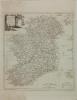
map / Ireland Divided into its Provinces and Counties, drawn from the latest surveys by Thomas Kitchen
Map of Ireland, early 19th century. Titled ‘Ireland Divided into its Provinces and Counties, drawn from the latest surveys by Thomas Kitchen, Geographer , Hydrographer to His Majesty'. Published by Alex Hogg at the King’s Arms, 16 Paternoster Row, London. Numbered in corner 34.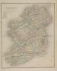
map / Ireland
Map of Ireland, 19th century. Titled ‘Ireland’. By J. & C. Walker. Published by Longman and Co., London. Colour. Numbered in corner 54.