Historical Collections Online
Search our Historical Collections Online, a sample of 10,000 artefacts from the National Museum of Ireland’s Historical, Military and Easter Week Collections, published as part of the Decade of Commemorations.
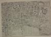
map / An Exact Survey of the City and Suburbs of Dublin, 1756
Map, Dublin city, showing St. Stephen’s Green to The Castle as the centre. Numbered T3. Part of An Exact Survey of the City and Suburbs of Dublin. In which is expressed the ground plot of all publick buildings, dwelling houses, ware houses, stables, courts yards etc, by John Rocque, Chorographer to...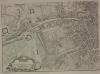
map / An Exact Survey of the City and Suburbs of Dublin, 1756
Map, Dublin city, showing James’ Street, Thomas Street and City Basin as the centre. Numbered T4. Part of An Exact Survey of the City and Suburbs of Dublin. In which is expressed the ground plot of all publick buildings, dwelling houses, ware houses, stables, courts yards etc, by John Rocque,...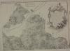
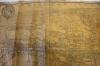
map / An Actual Survey of the County of Dublin, 1760
Map, showing the County of East Meath and part of the County of Kildare. Numbered C1. Part of An Actual Survey of the County of Dublin, on the same scale as those of Middlesex, Oxford, Barks and Buckinghamshires, by John Rocque, 1760. To the High Puissant and Most Noble Prince John Duke of...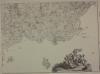
map / An Actual Survey of the County of Dublin, 1760
Map, showing North County Dublin, Ireland’s Eye and Lambay Island. Numbered C2. Part of An Actual Survey of the County of Dublin, on the same scale as those of Middlesex, Oxford, Barks and Buckinghamshires, by John Rocque, 1760. To the High Puissant and Most Noble Prince John Duke of Bedford,...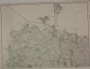
map / An Actual Survey of the County of Dublin, 1760
Map, showing part of the County of Kildare. Numbered C3. Part of An Actual Survey of the County of Dublin, on the same scale as those of Middlesex, Oxford, Barks and Buckinghamshires, by John Rocque, 1760. To the High Puissant and Most Noble Prince John Duke of Bedford, Marquis of Tavistock and...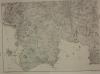
map / An Actual Survey of the County of Dublin, 1760
Map, showing East County Dublin,The Bay, the city and Howth. Numbered C4. Part of An Actual Survey of the County of Dublin, on the same scale as those of Middlesex, Oxford, Barks and Buckinghamshires, by John Rocque, 1760. To the High Puissant and Most Noble Prince John Duke of Bedford, Marquis of...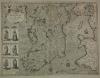
map / The Kingdome of Ireland, 1610
Map of Ireland, early 17th century. Titled ‘The Kingdome of Ireland’, divided into severall Priovinces, and then again divided into Counties. Newly described. Performed by John Speede and are to be sold in Pope’s Head Alley by John Sudbury and George Humble. Dated 1610. With illustrations of the...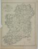
map / Map of Ireland, 1837
Map of Ireland, 19th century. Titled ‘Map of Ireland’, divided into Provinces and Counties, shewing the Principal Roads, Railways, Rivers and Canals, and the distance in Irish Miles and Furlongs of each city and Post Town from Dublin. For Lewis’s Atlas of Ireland. Drawn by R. Creighton, engraved by...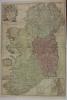
map / Ireland, 1712
Map of Ireland, early 18th century. Titled ‘Ireland’, corrected from the latest observations, divided into its Provinces, Counties and Baronies. Shewing the Principal Roads, and the Distances of Places, in Common reputed Miles by Inspection, Where Barracks are erected etc. By John Senax F.R.S., and...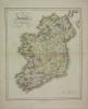
map / Ancient and Modern Ireland, 1821
Map of Ireland, 19th century. Titled ‘Ancient and Modern Ireland’, drawn and engraved for Dr Playfair’s Atlas. Engraved by B. Smith, Walworth, near London. Published by Macredie Skelly & Co., Edinburgh, 1821. Colour. Numbered in corner 45.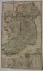
map / A New Map of Ireland, 1714
Map of Ireland, 18th century. Titled ‘A New Map of Ireland’, divided into its Provinces, Counties and Baronies, wherein are distinguished the Bishopricks, Borroughs, Barracks, Bogs, Passes, Bridges & etc, with the Principal Roads, and the common reputed miles. According to the newest and most exact...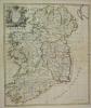
map / A New Map of Ireland, 1720
Map of Ireland, 18th century. Titled ‘A New Map of Ireland’, from the latest observations, by John Senax, inscribed to the Roght Honourable Simon Lord Lovat. 1720. Colour.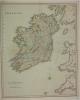
map / Ireland
Map of Ireland, 19th century. Titled ‘Ireland’, published in London by Henry Teesdale & Co., 302 Holborn. Colour. Numbered in corner 46.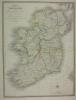
map / Ireland, 1841
Map of Ireland, 19th century. Titled ‘A Map of Ireland’ divided into Provinces and Counties’, shewing the Great and Cross Roads, with the distances of the principle towns from Dublin. Also the Steam Communications from the Out Ports, and the average time of passage. Published by J. Wyld (successor...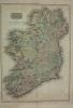
map / Ireland, 1813
Map of Ireland, early 19th century. Titled ‘Ireland’. Drawn under the direction of Mr Pinkerton, by L. Herbert. Engraved by Neale at 352 Strand, London. For Pinkerton’s Modern Atlas. Published 13 September 1813 by Cadell & Davies of Strand and Longman, Hurst, Rees, Orme and Brown of Paternoster...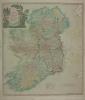
map / A New Map of Ireland’ divided into Provinces, Counties, 1798
Map of Ireland, late 18th century. Titled ‘A New Map of Ireland’ divided into Provinces, Counties, by Thomas Kitchen, Geographer, Hydrographer to His Majesty. Published 12 May 1798 by Laurie & Whittle, No. 53 Fleet Street, London. Colour. Numbered in corner 33.
advertisement / The Historical Atlas of Ireland, c.1862
Printed notice, advertising the publication of ‘The Historical Atlas of Ireland’. Containing The Atlas of Ulster, executed in 1609, in 31 maps. Two ancient maps of Ireland circa 1566. Copy of a portion of an ancient manuscript in the British Museum by Dean Laurence Nowell, being the text to...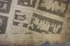
map / Dublin Sheet 21, 1840
Ordnance Survey map of the city of Dublin Sheet 21. The names of the various wards and parishes are printed around the edge of the map. Printed below the map is “Surveyed in 1838 by Captain Bordes & Tucker, R.E. & Engraved in 1840 under the direction of Captain Larcom, R.E. AT THE ORDNANCE SURVEY...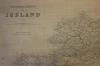
map / Ireland, 1905
An Ordnance Survey map of Ireland,mounted on a wooden pole for hanging. Published by the Director General at the Ordnance Survey Office, Phoenix Park, Dublin, 1905.